Generate the cell boundary in latitude/longitude coordinates of an H3Index cell
This operation is performed by function h3ToGeoBoundary. See the comments in the function source code for more detail.
The conversion is performed as a series of coordinate system conversions described below. See the page Coordinate Systems used by the H3 Core Library for more information on each of these coordinate systems.
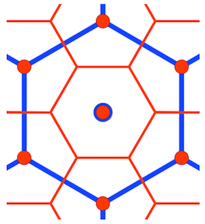
- We note that the cell vertices are the center points of cells in an aperture 3 grid one resolution finer than the cell resolution, which we term a substrate grid. We precalculate the substrate ijk coordinates of a cell with ijk coordinates (0,0,0), adding additional aperture 3 and aperture 7 (if required, by Class III cell grid) substrate grid resolutions as required to transform the vertex coordinates into a Class II substrate grid.
- The function
_faceIjkToGeoBoundarycalculates the ijk coordinates of the cell center point in the appropriate substrate grid (determined in the last step), and each of the substrate vertices is translated using the cell center point ijk. Each vertex ijk is then transformed onto the appropriate face and Hex2d coordinate system using the approach taken in finding a cell center point. If adjacent vertices lie on different icosahedron faces a point is introduced at the intersection of the cell edge and icosahedron face edge. - The Hex2d coordinates are then converted to latitude/longitude using
_hex2dToGeo.